Planet View: S15°37.753′ E130°28.510′
Street View: S15°37.753′ E130°28.510′
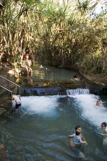
 We spent some time in Katherine (S14°19.067′ E132°25.252′)last weekend restocking our supplies and also getting a few minor items on The Tank taken care of. The Tank was due for an oil change and we also had one front hub that wouldn’t consistently disengage from being locked in 4WD so we figured that Katherine, being the third largest town in the Northern Territory, would be a good spot for mechanics. We called no less than seven mechanics before being able to get an appointment any sooner than five days wait! The fellas at Katherine Crash
  seemed for know Toyota Troop Carriers back to front and had our oil changed and hub fixed in no time. We also received a good dose of Northern Territory culture with a visit to the Katherine Hotel around 2:00PM on Friday afternoon. I think of the around 200 people in the pub we were probably two of the five white-skinned patrons, Lisa’s blonde hair sure motivated a few long looks from the local Aboriginals! I had a good chat to a few of the local black fellas about topics ranging from Christianity to the ensuing game of pool, definitely a good time to see a Territory pub in full swing on a Friday afternoon. We spent the night in Katherine at one of the caravan parks close to Katherine Hot Springs, springing for a pizza for dinner as it’s one of the things we can’t cook for ourselves when we’re on the road.

 Saturday morning we spent a bit of time in Katherine enjoying some of the last niceties of civilization with a cappuccino each and a fresh pastry for me before continuing west to Gregory National Park. Gregory is split into two sections across the Nungali and Wanimiyn Aboriginal lands, the most easterly portion of the park centers on the Victoria River and surrounding gorges. For our first night west of Katherine we camped at Victoria River Roadhouse (S15°36.969′ E131°07.736′), a small petrol station behind which is a large expanse of grassy campsites along the Victoria River. We spent the early portion of the afternoon on Saturday exploring Joe’s Creek, an easy hike through one of the Gregory gorges amongst Livistonia palms and cliffs decorated with ancient Aboriginal art. The escarpments in Gregory were just fantastic, the red cliffs contrasting with the green of the gums and deep blue skies. So much to take in… After our hike we veered off the highway and spent the balance of the afternoon at the Old Victoria River Crossing, Lisa filling her sketch book with drawings of the surrounds and me trying my hand at more fishing. I managed to catch a few juvenile fish in my yabbie pot and for the first time had a few bites on the line, but again finished the afternoon empty handed. A very relaxing spot though, good to be able to wind down after a week of go-go-going in Kakadu and trying to get everything with The Tank sorted in Katherine.


")


 After our night at Victoria River Roadhouse we ventured west to the larger portion of Gregory National Park. A quick check of the track conditions at Timber Creek and we started down the 40 kilometer unsealed road to Bullita Homestead. We’d planned to camp the first night at Limestone Gorge, a campsite 10 or so kilometers before Bullita, but due to extreme flood damage during the most recent wet season the campsite was closed. We still ended up driving down the gorge to have a look at the calcite formations cascading down the limestone faces of the gorge. On the walk to the calcite cascades
  is a reef of stromatolites, fossils of the oldest known forms of life on earth, hundreds of the fossils are spread across a concentrated section of earth, quite cool to see.

 We continued on to Bullita, staking out a campsite on the edge of the East Baines River for the night and
  then making the few hundred meters drive to the historic site of Bullita Homestead for lunch. The homestead was first used by pastoralists in the early 1800s, cattle was transported across the country by drovers from
  Queensland, a trek of over 3000 kilometers. Bullita remained as a working cattle station until the
  1970s, when it was abandoned by its owners after ravaging floods. It’s now a historical site, maintained by the National Parks Service. It was very interesting, replicas of the original cattle yards are on show and the homestead maintained in its original condition. The huge boab tree in the center of the property, one of many we’ve seen since being in Gregory, is engraved with names of stockmen and drovers who have worked the property over the centuries. The flies here in Gregory were absolutely relentless, swarms of them followed us everywhere we went, finding their way into nostrils, eyes and ears, so very frustrating. It’s the first time we’d broken out the fly nets that Lisa’s mum made for us before we left the States. I quickly discovered that no, you cannot drink liquids (beer) through the fly nets. The flies got under my skin so much at one point that Lisa got to have a good laugh at me screaming profanities at them in the middle of the bush. I guess I was hoping they’d understand English swear words and leave me alone… We ate our dinner at Bullita inside our mosquito tent, a fine art to enter the tent holding a plate of food and not have any flies make it through the opening flap!


 Today we tackled the Bullita Stock Route, a 92 kilometer 4WD track beginning at our campsite at Bullita Homestead and finishing up halfway back toward Timber Creek. The route is rated as ‘difficult’ by one of the 4WD guides we have and is also a one way loop, so we were crossing our fingers that we’d be up to it. The route began with a long but relatively shallow river crossing across the East Baines River, a little unnerving as we dropped into a hole or two during the crossing, but we made it out unscathed. The first 10 or 15 kilometers of the track was very slow going, a lot of the dry creek beds along the route were covered in large, jagged rocks and we had to traverse a long section of steep limestone steps as we dropped down Spring Creek Jump-up. Lots of time in low-range… It took a bit of cajoling for me to get Lisa behind the wheel down the steps to take some photos, but once she was used to letting The Tank’s own weight propel it down the steps in low-range it was smooth sailing. The Tank really showed us it’s abilities today, handling the jagged and steep sections of the trail with ease, an awesome vehicle when in its element.


 The Bullita Stock Route traversed some beautiful country, forever changing as we progressed, from grassy plains covered with gums and boabs to lush creeks lined with pandanus palms. The entire day we encountered only one other vehicle so were lucky to be able to experience the rugged country on our lonesome. Quite a treat to see the Oriental Hotel Boab Tree (pictured here to the right), a favorite stop-off for drovers of yesteryear with their favorite pubs and hotels in Australia’s Top End carved into the massive tree’s trunk. The other main river crossing of the track was another across the East Baines River, the second crossing dropping down
 a near vertical bank into marshy swamp and finally across the river. Both our hearts were pumping in unison as we dropped down the bank, amazing that neither the bull bar or rear bumper didn’t end up buried in the track! We made a slight detour to a spot 10 kilometers down a side road called Drover’s Rest, a favorite resting stop for drovers pushing cattle north to the slaughterhouses at Wyndham. It was along the Drover’s Rest side track that we came across the biggest red kangaroo either of us has ever seen. He was well beyond six feet tall when standing up, puffing his chest out at us to let us know we were on his turf. If the two females with him hadn’t hopped off into the bush I imagine he would have stood there all day letting us know who’s boss! Unfortunately I couldn’t get my camera out quickly enough for a shot of him.
 We’d planned to stay the night at Drover’s Rest but the campsite was located next to a murky, stagnant section of a tributary of the East Baines River and we thus decided to push on toward Timber Creek. Our last night in Gregory we’re spending alongside the Victoria River west of Timber Creek, a nice campsite in the north-western reach of the National Park called Big Horse Creek (S15°37.753′ E130°28.510′).
  We almost lost our dinner to the eagle pictured to the right, we left it out to thaw in the afternoon sun and I turned around to see the huge bird swoop and almost pick up our roo steaks with its talons! I dropped in a yabbie pot in the Victoria River (pictured to the left here) overnight tonight, fingers crossed for some cherabin in the morning. Off to Keep River tomorrow, likely our last stop in the Northern Territory before making our way across the border into Western Australia. We’ve been eating vegetables and nuts like crazy since restocking a few days ago in Katherine as we recently discovered that the quarantine station into Western Australia confiscates all fresh fruits, vegetables, nuts and honey!


This entry was posted on Monday, July 13th, 2009 at 9:24 PM and is filed under Australia, Northern Territory. You can follow any responses to this entry through the RSS 2.0 feed. Both comments and pings are currently closed.
HAPPY BIRTHDAY SAM!!!
July 17th, 2009 at 10:30 AM
Hi Sam/Lisa- Happy Birthday Sam– sorry can’t send you a cookie cake this year!. Wow- what a journey you are on.how lucky!!. BTW-I left RBS- and have been on gardening leave.. so i can eagerly follow you guys.. starting at Morgan Stanley on august 10th- hope we can catch up soon.. my email is wenrosen@optonline.net ( home) all the best and look forward to all the notes/photos. Wendy
July 20th, 2009 at 8:31 AM
Hi Sam and Lisa,
Awesome blog and photos. The Tank looks like it’s getting a good workout on those roads. Looks like you guys are having a blast. Thanks for sharing!
Heidi
July 21st, 2009 at 5:47 AM
[…] ran into a knowledgeable old fellow in Gregory National Park that clued us in on one of his favorite beach camping spots in Australia at an area called Quondong […]
August 24th, 2009 at 4:51 PM
[…] of the worst we’ve experienced, I think it was the first time we broke out our fly nets since Gregory National Park all the way back in July! Some beautiful wildflowers dotted across the landscape of the […]
December 3rd, 2009 at 9:16 PM
[…] We stopped off at the bakery in Bicheno yesterday morning to find the next article of ours on the shelves in the latest edition of Camping With Your 4WD. The spread pictured here chronicles our trip along the Bullita Stock Route through the Northern Territory’s Gregory National Park. […]
March 10th, 2010 at 12:11 PM