Jul 17
Photos from our time in Adelaide, Flinders Ranges, the Oodnadatta Track and Dalhousie Springs during June, 2009 as well as the Strzelecki Desert and Innamincka during July, 2010.
192 Photos
Photos from our time in Adelaide, Flinders Ranges, the Oodnadatta Track and Dalhousie Springs during June, 2009 as well as the Strzelecki Desert and Innamincka during July, 2010.
192 Photos


Issue six of Camping With Your 4WD has been out for a few weeks, but with our trip to Lizard Island and then time in Bedourie we haven’t been near too many newsagents. This article details our trip through Northeastern Tasmania with Lisa’s parents during February. A few cameo shots of Carol and Greg should be a good souvenir of their trip for them…
A collection of our photos from Lamington National Park, Coolangatta, Brisbane, Laidley, Coolum, Noosa Heads, Mount Coolum National Park, Noosa National Park, Sunshine Beach, Montville, Kondalilla Falls National Park, Rainbow Beach, Inskip Point, Fraser Island, the Great Sandy National Park, Bundaberg, Cania Gorge, Dawson River, Carnarvon Gorge, Eungella National Park, Mackay, Finch Hatton Gorge, Airlie Beach, the Whitsunday Islands, Toomulla Beach, Jourama Falls, Wallaman Falls, Murray Falls, Mission Beach, Henrietta Creek, Nandroya Falls, Millaa Millaa, Millstream Falls, Nerada Tea Plantation, Yungaburra, Lake Tinaroo, Port Douglas, Daintree National Park, Cooktown, Lakefield National Park, Musgrave, Laura, Iron Range National Park, Chillagoe-Mungana Caves, Davies Creek, Kuranda, Barron Falls, Cairns, Crystal Cascades, Babinda, Wooroonooran National Park, Josephine Falls, Behana Gorge, Lizard Island, the Great Barrier Reef, Normanton, Karumba, the Gulf of Carpentaria, Bedourie and Birdsville during May, June and July, 2010.
1002 Photos
 It’s a long way from Cairns to Adelaide. 2738 kilometers (1701 miles) miles if you take the shortest route. We made our way through Australia’s centre via the small cattle station outpost of Bedourie in southwest Queensland. It’s 1729 kilometers (1074miles) from Cairns airport – where we hopped off the plane from Lizard Island – to the remote western Queensland settlement of Bedourie. If you’re wondering why we went so far out of our way to pass through an isolated bush town in the middle of Queensland’s cattle country it’s to catch an event we learned of way back in May when we were in Coolum: the annual Bedourie camel races.
We spread the journey from Cairns to Bedourie over four days, first spending a night in our favourite tablelands town of Yungaburra on the shores of Lake Tinaroo. From Yungaburra we headed west across the Kennedy Highway, through the dilapidated settlement of Georgetown and further west toward Normanton. There wasn’t a whole lot to see on the way across the base of Cape York, seemingly endless plains of red dirt and scattered gums on either side of the blacktop. A good portion of the road between the tablelands and Normanton has only enough bitumen to handle the width of a single vehicle, so putting two wheels on the passenger side of The Tank onto the dirt shoulder at 100KPH (62MPH) to avoid oncoming cars definitely kept us on our toes.


 We spent our first night in the bush near Twenty Mile Creek about 30 kilometers (18.6 miles) east of Normanton, where we found a track off the highway leading into the bush as a service road for the Gulflander railway line. It was a tranquil spot next to a lagoon where we watched the vast array of birdlife go about their business in the afternoon sun. There were a couple of Brolgas poking their beaks along the waterhole’s banks when we arrived, awesome to see the towering birds up close as they hunted for food. The bush around us came to life as the sun waned, wallabies thumping their tails in the surrounding scrub and Green Tree Frogs coming out of hiding in the Pandanus Palms next to The Tank.

 Lisa had a yearning to see the Gulf of Carpentaria on our way back to Adelaide, in her opinion a circumnavigation of Australia just wouldn’t be complete without visiting the bight between Cape York Peninsula and the northern portion of the Northern Territory. So from Normanton we drove the 70 kilometers (43.5 miles) into the sleepy fishing village of Karumba, a spot popular with grey nomads on their way across the Savannah Way. We drove to Karumba Point to take a look at the murky waters of the gulf, amazed at the number of caravan-pulling vehicles in the middle-of-nowhere spot, all visiting for a shot at prized Barramundi in the surrounding estuaries. Amazing the number of Brolga and Jabiru hunting in the many waterholes around Karumba, when we saw these stork-like birds in the Northern Territory last year we thought they were so rare but the area around Karumba was absolutely inundated with them.


 Back through Normanton we stopped off at the giant crocodile monument and at the town’s only petrol station to top up The Tank. The old fella pictured here filling up our tanks reminded me a lot of my grandfather: everything at his place of business appeared to be an absolute jumble to the uneducated onlooker but I’m sure he knew exactly where everything was. His stockroom was an absolute mess of spare parts, old magazines, cash registers and other knickknacks. I don’t think I’d want to have any vehicle problems in Normanton!
We turned south in Normanton, past the Burke and Wills Roadhouse and south toward Cloncurry. We stopped off for a night just north of Cloncurry, setting up on one of the expansive cattle stations in the area. We were both amazed at the temperature differential with the 400 kilometers (248.5 miles) we traveled south from Normanton: at Twenty Mile Creek we were in shorts and thongs until we went to bed, whilst near Cloncurry we were in jeans and jumpers (sweaters) by 4:00PM!


 It was a long slog from Cloncurry to Bedourie. The first couple of hundred kilometers were a mix of boggy mud and bitumen, the former thanks to the unseasonal rain that this area of the country received a few days prior. Amazing just how desolate this area of the country is, in some areas we could look all around as we flew down the bitumen and see nothing but red dirt
  and blue sky. Not a single tree in sight between us and the horizon. The road between Boulia and Bedourie had only been open for a few days when we passed through, the rains had turned the unsealed sections of the road into deep, waterlogged bogs, impassable even in a high-clearance 4WD. When we traveled through we did actually get momentarily stuck in one or two spots, I had to hop out of the driver’s seat and crawl around the front of The Tank on the bull bar to lock the front hubs. That or wade in knee deep mud: no thanks. The rain brought the birds, the swamps amidst the desert were filled with Ibis and Brolgas, patrolling the shallows with their long beaks for food beneath. We also drove through some unbelievable swarms of palm-sized locusts, at certain points almost having to slow down because the density of the insects impaired our vision. There had to have been millions of the huge insects, bouncing off the windscreen like tiny pebbles as we mowed through the swarms. Hundreds of huge Whistling Kites flocked for a feeding frenzy on the locusts, the graceful birds of prey filling the skies alongside the road.


 It’s hard to imagine why towns like Bedourie actually exist. The surrounding cattle stations are effectively self sufficient, and the number one employer in the sleepy settlement of Bedourie is the city council (followed by the shire of Diamantina!). There’s a whopping 100 residents of Bedourie, not exactly a thriving Channel Country town. The only pub in town was a hive of activity on the two nights we stayed, we had some memorable conversations with the locals, as we always seem to do in hole-in-the-wall towns. You know you’re in a small town when all the locals leave their wallets on the bar at the pub when they come in for a drink!


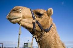
The Bedourie camel races were such a truly unique experience, we’re so glad we coordinated our trip back to Adelaide to see such a true blue Australian event. There aren’t too many places in the world where you can watch professional jockeys riding camels in the middle of some of the biggest cattle 
 stations on the planet! The camel
  harnesses were quite a sight, without reins the camel had to be relied upon to steer itself while the jockey held on for dear life behind the hump. There were more than a couple of occasions when we saw jockeys bucked off, camels turn around mid-race and start running the wrong direction, and camels leave the race track altogether! Such a hoot… There was a bookie at the races to keep things interesting, Lisa got quite involved as the day progressed, keeping tally of which jockeys and camels performed the best and jotting down race times for the winners. Unfortunately we didn’t pick any winners (that goes for your bet too Connie!), a few second places but we need a bit more practice at picking camels, it seems…


")


 An Outback race event just wouldn’t be complete without a wood chopping event. The CEO of the Bedourie council is a professional wood chopper, so as part of the annual races he organized a wood chopping event into which anyone in the crowd could enter. The event pictured here was full of local cattle stockmen, the gum rounds they had to chop through absolutely brought them all to their knees. It looked like amazingly hard work, once they made their way to the centre of each
 log the pace really slowed and by the end of it most of them could hardly lift their axes. One of the boys from Glengyle Station – located roughly 50 kilometers south of Bedourie – took the honors in the men’s event while the out-of-towner pictured to the right took the women’s crown. The MC mentioned that a professional wood chopper would make their way through similar logs in 30 to 40 seconds. That’d be something to watch!


 After a dip in Bedourie’s artesian hot springs just next to where we were camped, we finished up our day with another night at Bedourie’s Royal Hotel. We shared the pool table with a couple of Aboriginal stockmen working at one of the surrounding cattle stations, through the course of the night we discovered that they were both from Mount Barnett up in the Kimberley and were excited to hear that we’d visited their homeland when we visited Manning Gorge last August. One of the stockmen had placed second in the saddle bronc riding at the previous weekend’s rodeo, evident from the sizeable gash he had extending down one side of his face. A great stop off on our way south, very memorable to see those gangly camels careening down the muddy race course in the middle of the desert…

The northernmost of the Great Barrier Reef Islands, Lizard Island was a stopping for point for Captain James Cook on his voyage in 1770 and named for the prolific population of monitor lizards that inhabited (and still inhabit) the island. Today the island is a National Park and houses the luxurious Lizard Island Barrier Reef Resort, an all-inclusive slice of paradise nestled in the foredunes at the northern end of the island. Boasting some of the best Black Marlin fishing in the world, access to some of the most lauded of the Great Barrier Reef’s SCUBA diving locations, exquisite all-inclusive accommodation and beautiful beaches dotted around the island, we absolutely couldn’t have dreamed for a better spot to wind up our journey around Australia.


 An hour by plane or 15 hours by boat from Cairns, we spent five nights on the island with my mum, her partner Steve and his son Oliver, who made the trip from central California. We all met in Cairns the afternoon before catching a small Hinterland Aviation Cessna north to Lizard Island, a beautiful flight over the Great Barrier Reef and some of the islands between Cairns and Cooktown. The brilliant turquoise colour of the ocean in this area of the country is quite spectacular. As we descended and banked around Lizard Island all of us were in awe at the beautiful fringing coral reefs visible through the crystal clear water.

 Our pampering didn’t take long to kick in after landing: met by one of the resort concierges we were escorted to a waiting coach as soon as we disembarked and all given cool, scented flannels to wipe our hands and faces in the
  humidity. The resort itself is set at the northern end of the island, a collection of private suites – most with ocean view of either Anchor Bay or Sunset Beach – connected to the main dining area by a series of pathways
  through the tropical flora. The facilities included a tennis court, a beautiful pool, in-house gym, day spa and a beach activities hut where small catamarans and dive gear were at our disposal. After a welcoming iced tea and introduction to some of the staff we were all escorted to our accommodation, Lisa and I had a beautiful suite overlooking Sunset Beach while our partners in crime had adjacent villas overlooking Anchor Bay. Lisa wasn’t quite sure what to do first: spend some time in the double-headed shower, attack our well stocked mini-bar, lounge on our deck with our private view of Sunset Beach or just relax on the down pillow of our king bed!


There’s a lot that goes into running the resort operation on Lizard Island. At any time there’s between 50 and 80 staff living on the island to tend to the guests. It’s somewhere we’d both  happily return one day, the resort staff were all fantastic and a lot of effort goes into making sure that every guest is catered for. We couldn’t have asked for better accommodation whilst on the island, the view of Sunset Beach and all the beautiful sunsets were just something else. It was a very special spot, Rainbow Bee-Eaters would come in every afternoon and feed on insects just next to our balcony and the plethora of large lizards on the island were quite a sight.
We didn’t quite know where to start when we came across the bar pictured below on our first night at dinner. With a healthy selection of signature cocktails and plentiful choices of almost any spirit we could think of, we all enjoyed sampling some of Josh’s (the bartender) concoctions before and after dinner each night. One libation of particular note was the digestive Chartreuse that Josh had Lisa try one night after her  meal, a 110 proof French liqueur that immediately opened the sinuses with its unique aroma. The food throughout our stay was an absolute highlight. The breakfast menu stayed constant with a selection of six or so dishes – my staple was usually a Moreton Bay Bug omelet or Eggs Benedict – served alongside fresh fruit and freshly squeezed juice. For lunch and dinner the menu was constantly changing, four or five dishes to choose from at each sitting, we often couldn’t
  decide and just had to sample the entire menu! Just amazing food, I’m pretty sure Oliver has a photo of every meal and menu we were delivered. I took quite a few food photos (all of which are viewable in the album to the above left) and included some of the standouts below. I can honestly say that we’ve never eaten such an extensive array of delectable, well-presented food in our lives. The wine list was also quite a standout: an impressive array of wines from across the world, beers from every state in Australia as well as a few international brews, and a very accomplished bartender who could create just about any cocktail one could imagine. I took photos of the wine list included in the album to the above left, I’m pretty sure Lisa sampled almost every by-the-glass wine on offer!


 We made the most of the water sports on offer during our five night stay. Lisa and Jenni ventured out on the resort’s glass-bottomed kayaks during our first afternoon on the island, both commenting that it was a great way to see the reef from above. The shallowness of the reef in some sections of Anchor Bay in front of the resort dictated that the catamarans pictured here could only be taken out when the tide was above a certain level. Dodge tides for most of our stay – and high winds when the tide was high enough – unfortunately kept us from training for the America’s Cup team. We were, however, lucky enough to score a high tide with acceptable wind conditions on our last morning on Lizard, Oliver and I grabbing an early breakfast before heading out for a hell of a fun sail in Anchor Bay. We both realized quickly why the resort doesn’t allow the catamarans out in high winds: without a keel the boats easily find their way up on one hull. I had quite a giggle when I tacked in Watson’s Bay to see Oliver’s catamaran flipped on its side! Luckily he was able to right it quickly, such fun scooting across the water with the beautiful reef below. There’s a quick video of us sailing as part of the Lizard Island Movies blog if you have a fast internet connection…


 If you don’t enjoy being in the water then Lizard Island is probably not the place for you. Surrounded by the striking coral of the Great Barrier Reef and roughly an hour by boat to outer reef dive locations, Lizard is a snorkeling and SCUBA diving
  paradise. During our first full day on the island the five of us ventured out on M.V. Serranidae to the outer reef. After the rough trip between Lizard and the edge of the Great Barrier Reef we were all ready to hop in the water, the brilliant turquoise colour of the water was unbelievable. I’m pretty sure I heard Oliver say that he didn’t
  know the ocean could be such a striking blue. Our first dive site was the world famous Cod Hole, named for its resident Potato Cod. All of us were quite excited to jump in the water to explore the world below after running across a couple of Minke Whales on the boat ride to the outer reef. Steve, Oliver and I donned our SCUBA gear while the girls snorkeled on the surface. The giant Potato Cod were like big puppy dogs, the largest of them rubbing up against us as we explored the reef and quite happy for us to scratch him under the chin as he swam around us. An amazing experience, I’d never interacted with such friendly fish in the wild before.

 After our first dive we were dished up a brilliant lunch of roast chicken, king prawns and all manner of accompaniments. I’ve never eaten so well on a dive boat before in my life! Oliver jumped in the water with his underwater camera and snapped a video of the largest Potato Cod (see Lizard Island Movies) before we ventured north along the reef to nearby Dynamite Reef, named for its electric coral. Unlike Cod Hole, which is a slot in-between two reefs, Dynamite is a wall dive on the edge of a deep channel. While we did see some good-sized sharks in the water with us at Dynamite, we unfortunately didn’t come across any of the Black Marlin or Minke Whales during our dive that the dive masters sometimes see at the site. An awesome day, with underwater visibility in excess of 25 meters (82 feet) and some of the most amazing aquatic life on the planet it’d be hard not to have a memorable experience!

 On our return to Lizard Island one of the dive masters pulled out a large Scaly Mackerel from a compartment at the back of the boat, sloshing it in the water while we all got ready to disembark. Before long there was a small school of huge Tawny Nurse Sharks poking their heads out of the water for a feed, obviously quite used to humans as the dive master was able to give them all a pat on the nose. But the sharks weren’t the main event: after a few minutes a gigantic Queensland Groper reared its head and swallowed the three foot long mackerel whole. The groper was awesome, he had to have been six feet long and weigh in excess of 200 kilograms (440 pounds). Lisa, Oliver and I jumped in the water with the sharks and groper on another day, having quite an adrenaline-filled experience as some of the Black Tip and White Tip Reef Sharks got themselves a little frenzied at feeding time. There’s a video of us in the water with the sharks on Lizard Island Movies (third movie from the bottom), it’s quite long and has a lot of blue water but there’s plenty of sharks flying across the screen.


 We didn’t leave too many of Lizard’s snorkeling spots unexplored. Sunset Beach and Anchor Bay were adjacent to the resort, an easy walk to coral at our doorstep. Watson’s Bay housed the Clam Gardens and Watson’s Wall, both fun snorkeling sites with a plethora of colorful fish and even a turtle or two grazing along the sand next to the Clam Gardens. We hiked to the southern
  side of the island one morning to explore the huge expanse of Blue Lagoon, a sweeping area between Lizard and nearby Palfrey and South Islands. It was quite windy away from the protective hills shielding the resort, Lisa didn’t last too long in the water at Blue Lagoon but Oliver and I swam a couple of kilometers out to the wall demarking the edge of the coral with the open
  ocean. We made a beeline for the beach when Oliver spotted a Tiger Shark off in the deep blue, no thank you! The kids’ (Lisa, Oliver and me) favourite dive spot was at Mermaid Bay at the northeastern tip of the island. A location we could only access via boat, we dove at Mermaid twice and loved it both times. An unprotected wall drops off into the open ocean on the eastern side of Mermaid Bay, a few bommys on the edge of the wall were home to an unbelievable number of colourful reef fish. We were lucky to see some bigger pelagic fish cruise by when diving at Mermaid both times, some of the biggest Trevally I’ve ever seen and flighty mackerel whipped by in the distance a few times. On our second dive at Mermaid we all saw a giant Loggerhead Turtle cruising the ocean floor in the deeps. I dove down to have a closer look, Oliver and Lisa both commented that the turtle’s head was at least as big as mine.


")


, Anchor Bay (far), Palfrey Island (island on right) and South Island (island on left)") Lizard Island is only small – a few kilometers across – but there’s a great hiking trail making its way up to the top of the only peak on the island. The walking trail to Cook’s Look was a roughly 1100 foot (335 metre) climb, the first half of the trail a steep clamber over sticky granite boulders. It was a little cloudy on the day we climbed the peak, had it been clear we would have had unparalleled views of the island, Blue Lagoon and adjacent Palfrey and South Islands. Regardless of the clouds it was a fun climb, all of us completely drenched in sweat in the near-100% humidity by the time we’d reached the top. A couple of days later Oliver found three thick books in his backpack, no wonder his bag was so heavy on the way up to the island’s peak!
Lizard Island is only small – a few kilometers across – but there’s a great hiking trail making its way up to the top of the only peak on the island. The walking trail to Cook’s Look was a roughly 1100 foot (335 metre) climb, the first half of the trail a steep clamber over sticky granite boulders. It was a little cloudy on the day we climbed the peak, had it been clear we would have had unparalleled views of the island, Blue Lagoon and adjacent Palfrey and South Islands. Regardless of the clouds it was a fun climb, all of us completely drenched in sweat in the near-100% humidity by the time we’d reached the top. A couple of days later Oliver found three thick books in his backpack, no wonder his bag was so heavy on the way up to the island’s peak!


 What an awesome way to cap off our journey along the Queensland coast! A truly amazing location, Lizard is a part of our trip that we’ll remember fondly for the rest of our lives. Thank you so much to Jenni and Steve for having the idea to bring us all together on Lizard for a week, we both had a blast. And thanks to Oliver for all the underwater photos and Lizard Island Movies, we both enjoyed meeting you and will no doubt see you Stateside in a few months!
[kaltura-widget uiconfid=”535″ entryid=”0_93muvkyx” width=”600″ height=”490″ addpermission=”3″ editpermission=”3″ /] [kaltura-widget uiconfid=”535″ entryid=”0_2wf98f54″ width=”600″ height=”490″ addpermission=”3″ editpermission=”3″ /] [kaltura-widget uiconfid=”535″ entryid=”0_n8l7iwpv” width=”600″ height=”480″ addpermission=”3″ editpermission=”3″ /] [kaltura-widget uiconfid=”535″ entryid=”0_47j5sagi” width=”600″ height=”480″ addpermission=”3″ editpermission=”3″ /] [kaltura-widget uiconfid=”535″ entryid=”0_qh01jvr2″ width=”600″ height=”480″ addpermission=”3″ editpermission=”3″ /] [kaltura-widget uiconfid=”535″ entryid=”0_xj9gtu22″ width=”600″ height=”480″ addpermission=”3″ editpermission=”3″ /] [kaltura-widget uiconfid=”535″ entryid=”0_d07dbr44″ width=”600″ height=”480″ addpermission=”3″ editpermission=”3″ /] [kaltura-widget uiconfid=”535″ entryid=”0_374qyzm9″ width=”600″ height=”480″ addpermission=”3″ editpermission=”3″ /]


 We’ve been skirting around Cairns for a few weeks now, exploring the Wet Tropics World Heritage Area to the south, Tablelands to the west and all the way up Cape York to the north. We arrived in town on Sunday after our trip across some very arid country from Chillagoe-Mungana Caves, stopping off to check out Davies Creek National Park on the way in. One of the many waterfall-fed gorges around Cairns, Davies Creek was a beautiful spot with a very powerful waterfall at its beginning. The angle of the lookout above the falls wasn’t the best for a photo, there was a serious amount of water cascading down the rocks…

 We also stopped off in Kuranda on the way down the mountains into Cairns. Kuranda is famous for its rainforest markets as well as being the point at which the Kuranda Skyrail disembarks. While I’m sure Kuranda would have been a quaint mountain village at one point in time,
  the immense influx of tourists and multiple daily tour buses passing through town has turned the markets into more of a tourist trap than some of the other brilliant markets we’ve visited on our travels (like the Yungaburra Markets we visited on Saturday). Since when has a ‘gourmet’ pie consisted of plain mince, gravy and pastry? Queenslanders just do not know how to make good pies, especially in touristy towns… A few kilometers past the centre of Kuranda lies the Barron Falls section of Barron Gorge National Park. The falls were an awesome sight, multiple strands of water cascading down the cliffs into the gorge below, I’ve seen photos of these falls during the wet season when they turn into a single massive torrent of foam. The boardwalk leading to the falls lookout was very well done, similar to some of the canopy walks we’ve done elsewhere on our trip for most of the way we were walking 20-30 feet above the ground through the jungle. A very different perspective on the rainforest. In 1935 Australia’s first underground hydro-electric station was built to harness the immense power of the floodwaters cascading over Barron Falls each wet season. It was replaced by the Barron Gorge Hydro-Power Station further down the gorge in 1963 after the construction of the Tinaroo Dam upstream on the Barron River.
 Cairns proper was a bit of tourist zoo. We kind of liked the place though, contrary to our preconceptions, with its esplanade lined with cafes and restaurants, plethora of well-priced drinking establishments and no shortage of interesting people to sit and watch. On our first night in town we treated ourselves to a nice dinner followed by a few drinks at the pub, we were still on camping time so were able to take advantage of
  all the restaurants offering 20-30% off the bill if you’re seated by 7:00PM. Not very often you can go to a restaurant and order two main meals with a jug (pitcher) of beer for ~$35!
With a couple of days to kill before my mum, her partner Steve and his son Oliver met us for our trip to Lizard Island we explored some of the Cairns surrounds after our initial night in town. The Crystal Cascades are a short drive west of Cairns, a beautiful gorge with multiple waterfalls and no shortage of swimming holes. It was early morning and still quite cloudy when we explored the gorge, but had it been hot it would have been an awesome place for a dip…


 From the Cascades we headed south of Cairns roughly 50 kilometers to the sleepy sugar cane town of Babinda. Babinda’s claim to fame is often being crowned the wettest town in the whole of Australia, a few years ago the tiny hamlet received almost 7000 millimeters (276 inches) of rain! Just west of town into the mountains is a beautiful swimming hole called the Babinda Boulders. A tranquil turquoise pool fringed by the rainforest on the edge of Wooroonooran National Park, we enjoyed lunch in the picnic area and couldn’t pass up a swim. The water was so clear I took my snorkel and mask down to the pool, spotting quite a few tortoises cruising along the sandy base of the pool. When we met Townsville locals Heath and Anna at Murray Falls a few weeks back they mentioned that the freshwater waterways in the topics are home to Australian Longfin Eels. I wasn’t expecting to see any at Babinda Boulders, but got quite a shock when I saw three or four of the at least meter-long (3.3 feet) eels cruising the pool in search of food! I thought one was trying to nip my toes but eventually figured that he was in search of food in the silt that my feet were kicking up on the bottom. The eels can supposedly get up to two metres (6.6 feet) in length and weigh up to 20 kilograms (44.1 pounds)!

 Our last stop of the day on Monday was at another of Wooroonooran National Park’s wonders: Josephine Falls. A gushing torrent of water and another popular swimming hole with the locals, the falls are a short walk through the dense jungle. It was late in the day by the time we’d arrived but the pool at the
  base of the first viewing platform would have been a fantastic spot for a swim. The water colour was quite spectacular, the pictures here don’t do it justice, such a brilliant turquoise at the base of the granite boulders forming the falls.
We traveled back to Babinda for the night from Josephine Falls, setting up camp at the town’s rest area on a welcoming patch of grass a short walk from the pub (I’m always pro camping areas that are walking distance to a pub!). We strolled into town after dinner to check out the night life, not much going on in Babinda on a Monday night but interesting all the same. At one of the pubs we were two of the three patrons at the bar, while the Babinda State Hotel was a little more lively with five or six other attendees. The free pool at the Babinda State Hotel kept us occupied for an hour or two, it was quite a hoot to watch some of the local Aboriginals play the pub regulars.


 On our way back into Cairns to meet my mum and Steve we figured we’d better not leave any of the major Cairns sights unseen, so stopped off at Behana Gorge roughly halfway between Cairns and Babinda. Another of the gushing waterways that has been commandeered by the Cairns Regional Council for water supply, Behana Gorge is accessible via a three kilometer (1.9 mile) walking track from the end of Behana Gorge Road. Quite a heart-pounding walk in the dense humidity, I took a lengthy swim in the pool at the base of one of the gorge’s falls and Lisa cooled her feet before we were on the road again on our way into Cairns.


 We came across our latest addition to the magazine shelves today with an article on our travels through Coffin Bay and Lincoln National Parks in the southern Eyre Peninsula just before Christmas last year. The article is in Australian 4WD Action issue 150 for anyone wanting to take a look for themselves!


 Cooktown is as far north in Queensland as one can travel on the pavement. Named after Captain James Cook when he stopped in the area in 1770, Cooktown is a sleepy collection of a few shops and hotels on the banks of the beautiful Endeavour River. After a quick stop in Cooktown for necessities (beer and fresh vegetables), as well as an awesome pie from a German lady selling them at a stall in the park next to the marina, we were back on the dirt, headed along Battle Camp Road north to the fabled Cape York Peninsula.


 We spent most of our time on Cape York at Lakefield National Park. Lakefield is Queensland’s second largest National Park, covering a whopping 542856 hectares. It’s a couple of hours’ drive northwest of Cooktown along Battle Camp Road. Nestled on the edge of Princess Charlotte Bay, Lakefield’s low-lying expanse effectively becomes an inland sea during the wet season, when the park is completely closed and all rangers evacuated. During the dry Lakefield is made up of an array of waterholes and deep pools in
  the multiple rivers that traverse its expanse, many of the holes are covered in beautiful lilies and fringed by towering gums. The National Park is home to one of Australia’s most concentrated populations of Estuarine Crocodiles, so while the waterholes and rivers were all very picturesque we made sure to keep our distance from the banks at all times! During the late 1800s what is now Lakefield was a major access route to the northern goldfields, after which the property was part of Laura Cattle Station before being purchased by the Queensland government and turned
  into a National Park.
Access from Cooktown along Battle Camp Road gave us our fill of water crossings, nothing strenuous but fun to watch some of the big trucks driving the road navigate through the murky pools. We shacked up for the night near Lakefield’s southeastern boundary, pretty  beat after a long day of driving. Lakefield’s
  myriad of camping areas were fantastic, our first night alongside Horseshoe Lagoon (S15°17.156’ E144°36.900’) was a brilliant spot near the water’s edge where we had a view of the lagoon all to ourselves. Lakefield is one of the few National Parks in Queensland where collecting firewood and campfires are permitted, so we enjoyed whiling away each evening with a few beers around the fire pit. The waterholes and river pools of Lakefield offer excellent fishing: Catfish, Barramundi and Freshwater Longtom abound before the floods of the wet come and flush everything out to sea. No fishing for us on our first night next to Horseshoe Lagoon though, there wasn’t any way to access the water without standing right next to the bank and we decided we’d rather keep our limbs intact than donate them to a conniving croc!


 There’s a lot of history attached to the area that’s now Lakefield National Park. The remains of the old Laura homestead have been quite well maintained by the Queensland NPWS and were an interesting stop for us as we traversed the southern portion of the National Park from Horseshoe Lagoon. The old photos of the original homestead erected inside the ruins show that Laura was quite a bustling station in its heyday, it would have been tough country on which to run cattle a hundred or so years ago.


 As we drove north on Lakefield Road we quickly noticed that in Lakefield where there isn’t water the ground is covered with termite mounds. As when we traversed the Northern Territory and Kimberley last year, the plains in Lakefield are covered with huge termite mounds in hues from orange to a metallic grey. They seemed to get larger as we moved north, some of the mounds we encountered on the Nifold Plains were at least as big as The Tank.
There’s not a lot to do but sightsee, drive and fish in Lakefield (I’m not complaining at all, it was a fantastic spot). We did  come across a walking trail near Kalpowar Crossing, a four kilometer (2.5 mile) stroll through the tall grasses lining the Normanby River. We both had adrenaline flowing when we had to make the crossing between two low-lying waterholes where there were a couple of big signs warning of recent crocodile sightings. We psyched each other up and ran the section of trail between the eerily still pools of water!


 A major highlight on our way through central Lakefield was the adjacent pools of water known as White Lily Lagoon and Red Lily Lagoon. As their name suggests the waterholes are canvassed with beautiful lilies, the towering Lotus Lilies of Red Lily Lagoon were quite an awe-inspiring sight. After taking in the two lagoons we backtracked a little to Midway Waterhole (S14°53.164’ E144°12.362’), a secluded pool in the Normanby River with only a single campsite on the banks a couple of meters above the water level. An awesome spot, we had it all to ourselves and I enjoyed the afternoon with a spot of fishing while Lisa broke out her sketch book. Unfortunately I didn’t manage to bring anything onto the bank at Midway but did hook a few Freshwater Longtoms which kept things interesting. While it was nowhere near as humid in Lakefield as in the jungles of the Daintree, it was definitely hot work getting camp setup and collecting firewood during the middle of the day. We were both thankful for The Tank’s shower, a quick rinse before dinner so refreshing and nothing like being able to nude it up in the middle of the bush!


 From Midway we continued north, stopping off at the beautiful Breeza Kennedy Waterhole next to the remains of Breeza homestead and then taking a bit of a detour to complete the quick walk from the old Bizant ranger station to Blue Lagoon. Blue Lagoon is covered in the same Lotus Lilies as Red Lily Lagoon, a nice walk through the bush past some picturesque waterholes to make it to the lagoon. We came across a brumby (wild horse) next to the tame Hann River Crossing, before tackling a little more water at the crossing of the Morehead River further north in the National Park. The Nifold Plains extending between Hann River and Saltwater Creek were quite spectacular, seemingly endless expanses of tall grass dotted with gigantic termite mounds. We ventured off the track a few times for photos next to the larger mounds, huge piles of dirt, amazing to think of the millions of ants working together to construct them.


 We spent our last night in Lakefield at the National Park’s northern end alongside 5 Mile Creek (S14°32.238’ E143°49.599’). Another spot where we had the bush to ourselves, setup a few meters above the water level it was more campfire and beers into the evening. We both spent some time fishing in the deeper pools of the creek during the afternoon, Lisa getting quite a fright when she found herself being stared down by an Estuarine Crocodile whilst standing well back from the bank. That spelled the end of fishing for Lisa that afternoon, instead she decided to shadow me along the waterway where I hooked a couple of Barramundi, the one I got onto the bank unfortunately a little undersize so he had to go back.

 We headed out from Lakefield early on our last morning in the National Park, motoring inland the roughly 50 kilometers to Musgrave Roadhouse on the Cape York Developmental Road (the main dirt road up the centre of the peninsula). The owner/operator of Musgrave was quite an interesting chap to talk with, the roadhouse has been in his family since 1892. Unfortunately the owner’s children all work in the city and aren’t interested in continuing the family business, so when he retires it will be quite the end of an era when Musgrave
  changes hands. Our original plan was to turn back south at Musgrave, hearing from a number of other travelers that making the 600 kilometer trek to the top of Cape York really wasn’t worth the effort. But we had a few days to kill and instead decided to venture further north to Iron Range National Park roughly 340 kilometers up the peninsula from Musgrave. Lisa made a quick call to her family to let everyone know we were still alive and I topped up the diesel tanks before hitting the dirt again.


 The drive to Iron Range was quite a mission. The 200 kilometers (124 miles) along the dirt road to the Iron Range turn off wasn’t bad, but the last 120 kilometers into Iron Range was slow going. Nothing impossible, but a lot of deep dips with water at the bottom, slick roads in the misting rain and the crossing over the Pascoe River gave us cause to sit back and have a think about things before attempting the ford. Iron Range was unfortunately a bit of a let down for us… While it is Australia’s largest swath of lowland rainforest, we were a little topped out on rainforests after our trip through the Wet Tropics World Heritage Area and Daintree during the previous weeks. The campgrounds left quite a bit to be desired, and to put the icing on the cake the weather consisted of misting rain and gale force winds
  when we arrived. We trekked out to Chili Beach (S12°37.797’ E143°25.725’) at the National Park’s northern end and setup in the jungle
  just back from the beach. The humidity was impenetrable, we both hardly slept at all in the sticky heat coupled with howling wind. Also sad to see the amount of rubbish that was washed up on Chili Beach, it must be something to do with the tides in this area of the coastline. Made us want to never use plastic again! I will say that it was quite fun picking up coconuts from the beach and hacking them open, the sweet coconut milk a welcome treat in the late afternoon before dinner. Definitely not worth the 690 kilometer round trip and two days of driving to and from Musgrave to see Iron Range. We should have taken your advice and turned around at Musgrave, John!


 After a marathon day of driving from Chili Beach down Cape York, we made it to the small settlement of Laura late in the afternoon on our last day in the area. The Laura Roadhouse allows camping on the grass behind the main structure, we setup for the night and enjoyed a proper shower, the first one in over a week (but we do use The Tank’s shower so we never get really on the nose…). We enjoyed a beer and informative chat with the young owner of the LandCruiser FJ pictured here. Hailing from Dubbo in New South Wales, the young bloke was employed as a freelance bull catcher by some of the stations on Cape York north of Laura. The stations in Queensland are allowed to catch cleanskin (unbranded) bulls and heifers to claim as their own. May sound straightforward,
  but when a station up here is often the size of a small European country without any roads to speak of, catching feral cattle is quite an undertaking. He explained that to catch bulls they cut the roof and windscreen off an old FJ like the one pictured here, encasing the trimmed-down vehicle in a cage of tubular steel to protect it from the bulls. On the front is attached a large padded ram or tyre. After chasing down a bull or heifer through the bush the ram is used to hit the animal on the run (preferably without breaking any of its legs), and while the animal is on the ground the bull catcher jumps out of the vehicle to tie up its hind legs before it can right itself. Full-sized bulls and heifers fetch $100 a piece from the station owners. Tough work for sure!
That’s it for Cape York, we’ve traveled as far north in Queensland as we’re going to go. A little rest and relaxation in the Tablelands is in store for us, before my mum and her partner come to meet us in a week or so for a few days on Lizard Island.

| S | M | T | W | T | F | S |
|---|---|---|---|---|---|---|
| 1 | 2 | 3 | 4 | 5 | 6 | |
| 7 | 8 | 9 | 10 | 11 | 12 | 13 |
| 14 | 15 | 16 | 17 | 18 | 19 | 20 |
| 21 | 22 | 23 | 24 | 25 | 26 | 27 |
| 28 | 29 | 30 | ||||