
 One of our main stops up north is Kakadu National Park, one of Australia’s most famous attractions and (I think) the only site listed as a World Heritage Area for both natural and cultural features. Kakadu is massive, it’s a third the size of Tasmania, and even though only a measly 3% is open to visitors we still took almost a week to explore all its wonders.
With The Tank laden with two full fuel tanks, 85 liters of water and enough food for a few weeks we left my cousins Margot and Sophie in Darwin on Sunday morning, headed for Kakadu. We made our way to the town of Jabiru in the northeastern corner of the park; Jabiru is a fully-functioning town with banks, a post office, supermarket and even a Holiday Inn built in the shape of a huge crocodile. More than one person recommended to us that we should spend a night at the Kakadu Lodge caravan park in Jabiru, it was certainly camping in style. The caravan park offers grassy camping areas (something that’s a bit of a luxury in the Northern Territory), a beautiful pool set amongst tropical palms, a bar that’s open between 4:00PM and 10:00PM as well as live music during the evenings in the dry season. We setup camp and made the roughly six kilometer walk between Kakadu Lodge and the Bowali Visitor Center, passing through an active controlled burn area on the way and earning a swim in the pool before dinner. As well as everything from chicken breasts to kangaroo steaks from Darwin’s Fannie Bay Meat Company we still had a few vacuum packed scotch fillets from Adelaide so dined on them sliced up over spinach salad (fresh fruit and vegetables is also a luxury for us when we’re near large towns with supermarkets).

 We headed out early from Kakadu Lodge, heading to the most northeastern section of Kakadu to view the Aboriginal art sites at Ubirr. We took a quick stroll around the Bardedjildji Walk
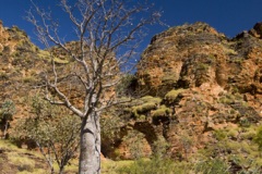
  loop along the eerie Alligator River, being rewarded with some fantastic views of the sandstone escarpments along the edges of the path. We’d also planned to take the 6.5 kilometer Sandstone and River Bushwalk from the end of the Bardedjildji Walk for supposed good views of the Arnhem Land escarpment but the track was unfortunately closed due to major bridge damage during the most recent wet season. We’ve found (the hard way) that we need to complete any morning activities by around 10:30AM up here in the Top End, otherwise the heat and humidity become just unbearable. We finished our morning walk and made our way to the Ubirr art sites for a leisurely stroll through the painted gorge. Some of the paintings are thought to be around 2000 years old, very cool to see all the Aboriginal art in its natural setting. The end of the Ubirr art loop walk makes its way to a lookout providing excellent views of Arnhem Land and the sandstone escarpments hemming the wetlands. It really gave us a feel for Kakadu from the lookout, red and yellow sandstone rocks overlooking lush green wetlands below.


 The plan was to spend our next night at Merl campground near Ubirr, but when we arrived we discovered that the campsites were located in thick, humid jungle brimming with flies and mosquitoes. So we kept moving and made our way to the Muirella Park campground next to Djarradjin Billabong. The Muirella Park campground is run by a local Aboriginal
 family who also operate night spotlight tours cruising the billabong as well as Aboriginal nature talks. I tried my hand at fishing for barramundi again at Djarradjin, but all I ended up doing is losing one of my lures to a shoreline tree. Very eerie fishing up here, I was very careful to stay at least 10 feet from the water’s edge, you never know what’s lurking just below the surface! After spending the heat of the day laying low at Muirella Park, we ventured back up the road to Burrunggui and Anbangbang for some more Aboriginal artwork and a view of the Arnhem Land escarpment in the sunset. Burrunggui and Anbangbang are the Aboriginal names for Nourlangie Rock, a lone standing piece of the escarpment on the edge of Arnhem Land. The local
  people request that Burrunggui and Anbangbang be used to describe the area, so that’s what we’ve used here instead of Nourlangie. The artwork at Anbangbang was fantastic, a great deal of the x-ray style Aboriginal rock painting for which Kakadu is so famous. It’s thought that the artwork at Anbangbang is approximately 1000 years old, only half the age of that at Ubirr. Anbangbang’s artwork has been maintained fantastically, some of the paintings are still very clear on the sandstone walls. The caves housing the Anbangbang paintings are thought to have provided sanctuary for the local Aboriginal people for over 20000 years! We hiked up to the lookout at Nawurlandja for a view of Burrunggui and Anbangbang during the late afternoon sun, some beautiful views of Burrunggui and Anbangbang as well as the distant southern extension of the Arnhem Land plateau.


 Sticking with our plan to complete any strenuous activity before around 10:30AM each day, we took a morning walk into Gubara Pools on Tuesday starting around 8:00AM. The temperature was perfect for the six kilometer out-and-back walk through a sandy creek bed to the monsoon forest at Gubara. Gubara is one of the few places at the base of the Arnhem Plateau with permanent water that doesn’t have estuarine crocodiles, so we felt comfortable walking through the forest next to the water’s edge. The
  pool edges were hopping with the rocket frogs we first encountered at Nitmiluk and I spotted a couple of huge catfish making their way through the water. Throughout the monsoon forest at Gubara were sections of two meter high debris wrapped around tree trunks and boulders, one of the most vivid demonstrations of the massive amounts of water that must flow through the rivers in Kakadu during the wet season. For the entire Gubara hike we were both amazed at the early morning bird choir throughout the bush, amazingly loud and so many different tunes. Most of the time the singers were hidden, however, so we had to enjoy the chorus without having too much of an idea from whom it was coming.


 crocodile at Yellow Waters") While our camp at Muirella Park was quite comfortable, we decided that the extra $5 a night for a campsite with access to a pool was worth it in the heat, so for the next two nights we shacked up at Gagudju Lodge Cooinda. It’s not much of a lodge, it’s basically a highly concentrated caravan park and headquarters of the famous Yellow Waters tours, but the unpowered campsites were quite hospitable located in the bush at
While our camp at Muirella Park was quite comfortable, we decided that the extra $5 a night for a campsite with access to a pool was worth it in the heat, so for the next two nights we shacked up at Gagudju Lodge Cooinda. It’s not much of a lodge, it’s basically a highly concentrated caravan park and headquarters of the famous Yellow Waters tours, but the unpowered campsites were quite hospitable located in the bush at 
 the rear of the property with access to the main lodge’s pool. On Tuesday we spent a couple of hours during the heat of the afternoon lounging by the pool
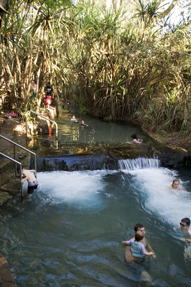
  (yes, I love the pool) before taking a sunset tour of the Yellow Waters billabong and South Alligator River. The cruise was amazing! Our tour guide Robin was fantastic, an absolute wealth of information not only on the history of Kakadu but also on all the animal and bird species we encountered during our two hour sunset trip. As Lisa’s mum commented to us (she was at Yellow Waters a few years ago), the cruise is very much like a Disneyland ride; from gigantic estuarine crocodiles to majestic white-breasted sea eagles, everywhere we looked offered a new and wonderful animal to behold. To all the people that recommended to us that we undertake a Yellow Waters tour, thank you very much!
 crocodile at Yellow Waters")


 crocodile at Yellow Waters")
 crocodile at Yellow Waters")


 crocodile at Yellow Waters")


 crocodile at Yellow Waters")


 Wednesday we made the trip into Jim Jim and Twin Falls, probably the two most famous waterfalls in Kakadu National Park. A short drive from Cooinda is the turn-off to the Jim Jim Falls 4WD track, a 50 kilometer corrugated dirt road followed by a further 10 kilometers of 4WD track. The final 10 kilometers were a lot of fun, the track was definitely 4WD only, a mix of deep sand, rocks and quite a few river crossings. Unfortunately Jim Jim Falls had already run dry for the season, the massive falls just a trickle, but the swimming pools at the base of the falls hemmed in by huge cliffs were quite a sight. We were contemplating hiking to the top of Jim Jim Falls, allegedly a strenuous seven kilometer hike, but after talking to a guide we ran into on the Jim Jim Falls hiking trail we instead decided to make the drive to Twin Falls and hike to the top of them instead. The
  Twin Falls track was another 10 kilometers of sand and water bars, with the longest water crossing of the day. At 50 centimeters deep, however, it didn’t get out hearts racing like our crossing in Litchfield. The hike to the top of Twin Falls ended up being quite strenuous, it was only a couple of kilometers to the top but we attempted it during the heat of
  the day so were pretty drained by the time we reached the pools. It was well worth it, we found a pool to ourselves and spent plenty of time cooling off. We didn’t actually get to see the falls at Twin Falls: they’re located at the end of a long plunge pool that is inhabited by estuarine crocodiles, the only way to see the falls is in a boat. Lisa drove back to the camp and gave us both quite a start when
  we attempted the longest creek crossing without 4WD low-range engaged properly. It’s no fun when you’re motoring through a crocodile-infested river and you hear a clunk, followed by your vehicle starting
  to shudder to a stop. Luckily we quickly realized what had happened and re-engaged the drive-train before losing all our momentum. Lisa was physically shaking at the end of that crossing, not quite her hyperventilation-at-the-sight-of-a-snake trick from Turkey, but she was definitely a little shaken up! Our neighbors at the campsite at Cooinda offered us fresh-baked pumpkin damper scones on our return to camp, couldn’t have asked for a better way to end a long day of hiking and 4WD tracks…


 Today, our last full day in Kakadu, we left our luxurious caravan park at Cooinda and continued south to the waterfall at Maguk (Barramundi Gorge). Located 12 kilometers off the main road along an unsealed road, Maguk’s falls are a quick walk through the monsoon forest from the end of the driving track. Unlike Jim Jim, Maguk’s falls were flowing with plenty of water, though we didn’t stop for a swim as we had ground to cover before reaching our resting place for the night at Gunlom. Gunlom was recommended to us by my cousin Margot, located 37 kilometers off the main road
  along a very corrugated dirt road that crossed a number of (currently dry) creeks. One of the creeks had water depth markers up to four
  meters, if anyone knows a vehicle that can tackle a water crossing with water four meters deep please let us know! The campsite at Gunlom is located right next to the falls, unfortunately the falls there had also exhausted themselves for the dry season. The facilities at Gunlom have a fantastic grassy day use area shaded by gums next to the falls’ plunge pool. Maintaining our wariness about swimming in pools at the base of the Arnhem Land escarpment, we hiked the kilometer or so to the top of the falls and were rewarded with the best swimming holes we’d encountered in Kakadu. A series of four or five pools are located at the top of Gunlom, bordered by trees for shade and plenty of cliffs to launch off for those so inclined. An hour cooling off at the top of the falls was a great way to cap off our stay in Kakadu.


 From here we’ll probably take a day or two in Katherine getting a couple of minor issues with The Tank checked out before heading west to Gregory National Park. I’m glad we allotted a week to spend in Kakadu, the place really is massive and requires a good amount of time to take it all in. It has everything you could ask for in the Top End: wetlands, billabongs, waterfalls, Aboriginal art, and some of the most amazing wildlife we’ve seen on our travels thus far. That Yellow Waters boat tour is something neither of us will ever forget, being able to get six feet from a wild 18 foot long estuarine crocodile (we were in a boat, of course) was a pretty unforgettable experience.

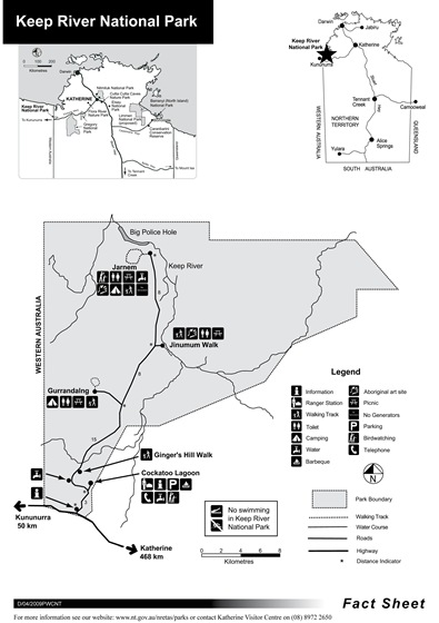
 We spent a few days in Kununurra, winding down from our trip through Kakadu, Gregory and Keep River National Parks. Kununurra is around 40 kilometers west of the Northern Territory/Western Australia border, a relatively new town founded to support the Ord River Scheme when it was launched in 1963. (For those of you that don’t know [and I didn’t before visiting the area] the Ord River Scheme involved the damming of Lake Argyle, now Australia’s largest man-made lake, to provide an irrigation source for the fertile soils surrounding the Ord River. The Ord stretches from Lake Argyle to the Arafura Sea to the north. The project began in 1963 and I believe the damming of Lake Argyle was completed some time in the 1970s.]


 On our way from Keep River National Park into Kununurra we took a scenic drive into Lake Argyle, a must-see recommended to us by a number of people who have ventured to this area. Lake Argyle is massive; in a country where water is often scarce and permanent lakes like Argyle are
  few-and-far-between, the huge expanse of water that is Lake Argyle was surely an eye-opener. Hemmed in by red and orange cliffs, the midnight blue of the lake was very picturesque. Local tour operators offer boat cruises as well as scenic flights of the lake, we even spied a few sailing boats moored in the harbor near the Lake Argyle tourist village.
 Kununurra itself was a very clean and tidy town. The place felt more like a staging area than an agricultural-centric country town: in every parking lot there were 4WD vehicles priming for trips across the Gibb River Road, and the mechanic shops were all full of rigs with all kinds of maladies resulting from their trip across the famed route, butchers in town offer free vacuum sealing of meats and there were no shortage of 4WD outfitters. As with the other towns up north, the only place to camp anywhere near town was at the caravan parks, all of which were full to the brim with grey nomads packed-in like tinned sardines. We joined the fray for our time in Kununurra,
 cordoning off a patch of grass for a few days and enjoying the caravan park’s pool during the heat of each day. We inquired about tours of the Argyle Diamond Mine, located a couple of hours drive south of Kununurra and responsible for the production of a third of the world’s naturally occurring diamonds, but tours of the mine were only available via $575 per person scenic flights which stop off at the mine. A bit too rich for our traveling blood! We did take a drive through the agricultural areas surrounding Kununurra
  fed by Lake Argyle, the myriad of waterways feeding the paddocks made us feel as if we could have been traveling through the California Delta. The fertile soil, sub-tropical climate and seemingly endless water supply allows the harvesting of almost anything, from melons through fruit and even some sugarcane. We found a fruit stand operated by some of the local producers where we stocked up on fruit and vegetables for the next week, some fantastically fresh and tasty produce on offer. During our tour of the


 Kununurra surrounds we also stopped off at Hoochery Distillery, sampling some of the 140-proof rum which seemed to evaporate in our mouths before we could swallow it! One nip was definitely enough for both of us.
 that were used to decorate our campsite to frozen chocolate cake from Darwin. The day I started on my way downhill is one I’ll always remember. And, of course, all the calls and emails from friends and family were very special too (thanks!). We enjoyed a dinner from my mum at a fantastic restaurant called the Pump House, located on Lake Kununurra in a converted lock pump house it made for beautiful views of Lake Kununurra and the sunset. The local barramundi and lamb shanks we ordered capped off a fantastic birthday and allowed me to forget that I’m now officially starting to get old!


 We spent some time in Katherine (


")


 crocodile at Yellow Waters")


 crocodile at Yellow Waters")


 crocodile at Yellow Waters")
 crocodile at Yellow Waters")


 crocodile at Yellow Waters")


 crocodile at Yellow Waters")


")


")


 at our campsite at Leliyn")